Mohawk River at Schenectady
Track river levels in and around Colonie, NY
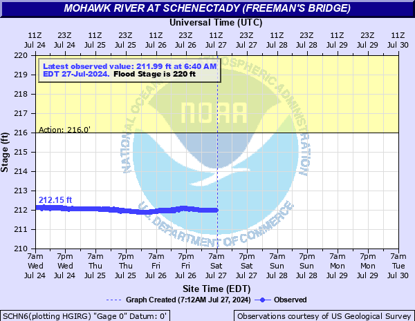
Latest Observation
2:25am EDT -- July 11, 2026
Current Stage:
212.01 ft
Current Flow:
9,030.00 cfs
Historic Observations
Most significant stages and flows
Record Stage:
232.90 ft
Record Flow:
N/A
Flood Stage Categories
Benchmarks that define rising river impacts
Action: 216.0 ft
Minor: 220.0 ft
Moderate: 222.0 ft
Major: 224.0 ft
| Time/Date | Stage | Flow | Category |
|---|---|---|---|
| 2:20am EDT -- July 11, 2026 | 212.01 ft | N/A | Normal |
| 2:15am EDT -- July 11, 2026 | 212.01 ft | N/A | Normal |
| 2:10am EDT -- July 11, 2026 | 212.01 ft | N/A | Normal |
| 2:05am EDT -- July 11, 2026 | 212.01 ft | N/A | Normal |
| 2:00am EDT -- July 11, 2026 | 212.01 ft | N/A | Normal |
| 1:55am EDT -- July 11, 2026 | 212.01 ft | N/A | Normal |
| 1:50am EDT -- July 11, 2026 | 212.01 ft | N/A | Normal |
| 1:45am EDT -- July 11, 2026 | 212.01 ft | N/A | Normal |
| 1:40am EDT -- July 11, 2026 | 212.01 ft | N/A | Normal |
| 1:35am EDT -- July 11, 2026 | 212.01 ft | N/A | Normal |
Normal: The water surface is below the top of its banks.
Action: The water surface is generally near or slightly above the top of its banks, but no man-made structures are flooded.
Minor: Minimal or no property damage, but possibly some public threat (e.g., inundation of roads).
Moderate: Some inundation of structures and roads near stream. Some evacuations of people and/or transfer of property to higher elevations.
Major: Extensive inundation of structures and roads. Significant evacuations of people and/or transfer of property to higher elevations.
Flood Stage Impacts
226.41 ft.: Water reaches the same level as was reached with Tropical Storm Irene in 2011.
226.00 ft.: The North Ferry Street gage reads about 230 feet. Water floods the former Alco plant area on Erie Boulevard Extension, Edison Avenue and Van Guysling Avenue, Broadway between Edison Avenue and Clinton Street, and River Street. National Grid substation at River Street requires protection. In Scotia Schonowee, Washington, and Livingston Avenues are flooded and water is in homes throughout the area. Collins Park is flooded.
222.00 ft.: The North Ferry Street gage reads about 226 feet. Water floods three fourths of Ingersoll Avenue, half of North Street, Ferry Street, East Front Street, and River Street. National Grid substation protection is necessary. In Scotia Schonowee Avenue is flooded and water is in yards and basements.
221.00 ft.: The North Ferry Street gage reads about 224 feet. Water is in the Stockade neighborhood between Ingersoll Avenue and Ferry Street. The area west of Erie Boulevard and south of State Street floods. In Scotia water approaches Schonowee Avenue.
220.00 ft.: The North Ferry Street gage reads about 223 feet. Water is just in Riverside Park in the Stockade area. In Scotia about half of the Jumpin Jacks parking lot is flooded and water is in Freedom Park.
219.00 ft.: The North Ferry Street gage reads about 222 feet. Water covers the riverside walkways at the Casino at Mohawk Harbor.
218.00 ft.: The North Ferry Street gage reads about 221 feet. Water is near Ingersoll Ave and Riverside Park. In Scotia water enters the Jumpin Jacks parking lot.
217.00 ft.: The North Ferry Street gage reads about 220 feet. Water floods the access ramp to Schenectady Community College under the Western Gateway Bridge.
216.00 ft.: The North Ferry Street gage reads about 219 feet. Water is near the access ramp to Schenectady Community College under the Western Gateway Bridge.
215.00 ft.: The North Ferry Street gage reads about 217 feet. Pumping is needed to keep water out of the community college parking lot.
Hydrograph
Gauge Location
Source National Water Prediction Service